The CIVITAS Initiative
The Route 100 project was planned as a CIVITAS Initiative project. The CIVITAS Initiative is an organization co-financed by the European Union that engages local sustainable mobility projects in cities throughout Europe. The organization’s aim is to support the implementation and evaluation of innovative strategies for sustainable transportation. Each of these projects is referred to as a ‘measure’ and CIVITAS has thus far tested over 800 different sustainability ‘measures’ in over 60 demonstration cities. The City of Aalborg joined the CIVITAS Archimedes project from 2008 to 2012. Six other demonstration cities were involved with the Archimedes project and each focused on creating innovate transportation systems in mid-sized cities that are safe, sustainable, and efficient. In Aalborg, sixteen 'measures' were tested and one of the 'measures' was the implementation of Route 100. The Route 100 project has the title “Cycling Motorway” and is CIVITAS measure number 51.This project was funded
- Free flow conditions for cyclists: The route should minimize unnecessary stops and exhibits clear priority for bicycle riders.
- Traffic Safety: Bicyclist using the route should be safe.
- Visibility and Service: Extra service should be provided along the route to increase the allure of bicycle commuting.
Goals for Route 100
This project was planned with three primary goals in mind. These goals were developed in collaboration between the CIVITAS Initiative and Aalborg Kommune, reflective of the city-wide goals for the future development of bicycle facilities.In order to achieve these goals, the city created a “tool box” of innovative initiatives to make bicycle commuting to the campus more attractive. The initiatives developed are reflective of the three goals and aim to improve the journey between the City Centre and the Aalborg University campus by making the journey more efficient, safer, and by implementing additional services to riders along the route.
A total of seven initiatives were planned and implemented along the route. To augment the success of the suite of innovative initiatives, the asphalt was repaved on portions of Hadsundvej and new bicycle lanes were stripped along Bønnenesgade and Riishøjvej. Three separate sources of funding were used in order to implement the improvements… Half of the funding was provided from the EU, via the CIVITAS Initiative. Another thirty-three percent came from Cykelpuljen ("the bicycle pool"), a national funding source for bicycle projects throughout Denmark. The remainder was paid for by Aalborg Municipality tax dollars. Construction on the Route 100 initiatives began in August 2010 and each was completed by Spring 2011.
As the two outside funding sources require post-implementaiton evaluation, the Municipality implemented a survey shortly after the construction of the last initiative in 2011. A total of 300 Route 100 users responded to the survey and an evaluation was done of the facility, based on the results of the survey. Respondents were asked if they were familiar with each individual initiative, as well as being asked how important they feel each initiative is on a scale of 1 to 10.
Route 100 Initiatives and Evaluation
Although different than the purpose of the users survey implemented for my Get Your Kicks on Route 100 research project, my research partner and myself repeated these basic questions in our recent survey. The purpose for doing so was to investigate whether opinions have changed, for better or worse, since the initial survey was given 2011. Our online user survey closed on December 13, 2013 and we received responses from 172 individuals. As I prepare to analyze the results of this survey, I have reviewed the 2011 survey results and evaluation.Each initiative designed and implemented as a part of measure 51 is described below, with details on their intended purposes, how they meet the project goals, and what was found during the 2011 evaluation. More information can be found on the CIVITAS website, including the survey questions, the measure 51 progress report, and complete 2011 evaluation.
(1) Reorganization of Bicycle Flow at Bus Stops
Along Hadsundvej, the grade-segregated bicycle lane has been reconstructed wherever bus stops are located. Previously, bus passengers stepped directly off the vehicle into the bicycle lane. Under these circumstances, bicyclists were required to yield to alighting passengers who were in turn required to look out for passing bicyclists. The stated purpose of this initiative is to allow bicyclists to continue riding on their path without needing to stop. Passengers are now provided a small refuge area on the road-side of the bicycle lane. This space allows them to safely step off of the bus with a decreased risk of being hit by a bicyclist. |
| (10/12/2013 | Bus Passenger Waiting Area on Hadsundvej | Credit: Franziska T.) |
According to the 2011 evaluation, 63% of respondents were
aware of this initiative and 49% feel that the new infrastructure is important,
with only 13% believing that it is unimportant. This upgrade was intended to
meet the first two goals developed for CIVITAS measure 51. Providing this
refuge improves the safety of both bicyclists and bus passengers. Moreover, the
bicyclists are no longer required to yield at bus stops, providing that free
flowing conditions that the goals aim for.
Although the evaluation does not express this, it can be argued that this also meets the third goal of increasing the visibility and services for bicyclists. That there is a new addition to the roadway exhibits that alternative modes of transportation have been planned for to all roadway users. Providing this refuge island does not directly translate into a service for bicyclist, however one could argue that providing free flow conditions at these points translates into providing an extra service to riders.
Although the evaluation does not express this, it can be argued that this also meets the third goal of increasing the visibility and services for bicyclists. That there is a new addition to the roadway exhibits that alternative modes of transportation have been planned for to all roadway users. Providing this refuge island does not directly translate into a service for bicyclist, however one could argue that providing free flow conditions at these points translates into providing an extra service to riders.
(2) Segregated Bicycle Filter Lane, or the "Shunt"
This initiative was installed where riders coming from the
City Centre, headed toward the main campus of Aalborg University, are required
to make a right hand turn. Previously, riders were required to stop at the red
light, yield to perpendicular bicycle traffic, and turn when the light turns
green—there is no free right on red law for cyclists in Denmark, despite many
riders ignoring this fact. Now, this new infrastructure enables campus-bound
bicyclists to take a right-hand turn without waiting for a light. Moreover,
riders turning right are separated from riders going straight, minimizing the
potential conflicts with other bicyclists at the light.
This new filter lane—or shunt, as it is also referred to—enables
campus-bound riders to take the right-hand turn without needing to consider the
traffic light. One great benefit provided by this initiative is that bicyclists
carrying on straight are not longer blocking riders wishing to turn right,
which speeds up the flow through this intersection. As is planned, this
successfully achieves the first goal of providing free flowing conditions.
Interestingly, it is also not indicated that the existence of bicycle
infrastructure at all increase the visibility or provides an extra services to
riders. In my own interpretations of this filter lane, campus-bound riders are
not only riding without pause, they are more safe due to this specialized
infrastructure—meaning that, in theory, it achieves all three goals of measure
51.

According to the 2011 evaluation, 65% of respondents were
aware of this initiative and 57% feel that the new infrastructure is important.
This evaluation states that only 6% of respondents disagree that it is
important and it has been interpreted to be a highly important initiative in
comparison to the results of the others.
An interesting thing to consider, however, is that
bicyclists heading toward the city are not provided a similar facility. At the
point where campus-bound riders turn right, city-bound riders turn left. That
said, there are no priority services provided to those city-bound riders. These
riders must stop at the light, cross the street, and wait again for a green
light to continue on to Riishøjvej. None of the three CIVITIAS goals are met
for city-bound riders at this intersection. In fact, thinking back to my
initial ride of Route 100, this is the left hand turn I missed on my way back
to the city. While the shunt was important to me as I rode toward campus, the
lack of a mirror facility headed the other direction caused me confusion and
disorientation.
(3) Bicycle Counter on Hadsundvej
This bicycle counter was installed on Hadsundvej. The
counter displays which ‘number’ bicyclist to cross that point, as well as the
date and time, the temperature, the speed the bicyclist is traveling at, and
the estimated number of minutes until the passing rider will reach the
university campus. Whenever the temperature drops below zero degrees Celsius, a
snowflake icon is displayed on the counter, indicating that there is risk of
ice on the roadway.
Due to the nature of a bicycle counter, this initiative does
not have an impact on safety or help to provide free flow conditions for
bicyclists. It is however indicated that the bicycle counter is intended to
meet the third CIVITAS goal of increasing the visibility and providing extras
services for cyclists, but there does not appear to be an appreciation for the
service it provides. According to the 2011 evaluation, 65% of respondents were
aware of this initiative and most expressed that it was between 0-50% important
to their ride. These results exhibit that it has the lowest importance to
riders among the other implemented initiatives, despite it being a well-known,
large, visible piece of infrastructure.
 |
| (10/12/2013 | Bicycle Counter on Hadsundvej | Credit: Franziska T.) |
There are several reasons why the bicycle counter may not be
actively considered important to Route 100 users. For one, bicyclists passing
the counter are likely traveling at a speed that prevents them from digesting
more than one or two pieces of information presented to them. Of the
information displayed, the most important piece of information for a passing
bicyclist is the estimated number of minutes until reaching the Aalborg
University campus. Although the actual time might be considered equally
important, it is assumed that most riders are headed to this location and this
estimation may help signal to campus-bound riders that they will be early or
need to speed up to be on time.
The information indicated by the snowflake is also quite
useful, in that it could warn passing bicyclists to ride with more care on
potentially icy roads. This feature however is only useful if the passing
riders sees the symbol and understand what it means. Perhaps this is common
symbology for indicating icy conditions, but it may just as easily be
interpreted to simply mean that it may snow. Whether or not this will be
accurately by a bicyclists will influence how important that information is.
These two features can actively affect how riders are using the facility, but
if respondents to the survey did not feel the initiative is important, these
active uses were or are not fully appreciated by users.
One of the interesting passive uses of the bicycle counter
is that the count data can be downloaded on the internet. Ridership statistics
can be downloaded for the last 24-hour period or the last month at no cost.
However, this is not something that the vast majority of riders would be
interested in, or even be aware of—and this capability is not advertised on the
counter itself. This data also has limited use to an analysis of Route 100.
There are four similar bicycle counters located in the City of Aalborg, however
this is the only counter on this route. This is not necessarily a flaw—as it is
logical to spread these counters across the city—but it does mean comparing
ridership on the City Centre end to the Aalborg University end more difficult,
requiring manual counts taken in the City Centre.
(4) Automatic Air Pumps
There are two air pumps installed along Route 100. One is
located in the City Centre at Østerbro and Bonnesengade. The other bicycle pump
can be found adjacent to the bicycle counter on Hadsundvej. Both pumps have a
built in compressor, is activated by a button, and the tube is compatible with
different types of tire valves to accommodate an array of bicycles. Each of
these pumps is located on the west side of the street, indicating that they are
primarily provided for southbound bicyclists heading to Aalborg University
campus. Riders heading toward the City Centre of course have access to the
bicycle pumps, but this makes them inconvenient to access to northbound riders.
Similar to the bicycle counter, this initiative is aimed at
enhancing the visibility of bicycling by providing an extra service to riders.
The evaluation does not indicate this, but it may also be argued that providing
bicycle pumps along the route can positively influence traffic safety, as
riders now have the chance to pump up a low tire and prevent a potential
incident.
 |
| (10/12/2013 | Bicycle Air Pump on Bonnesensgade | Credit: Franziska T.) |
According to the 2011 evaluation, 77% of
respondents were aware of the bicycle pump on Hadsundvej and 49% know about the
pump on Bonnesensgade. This deviation in knowledge is reflect in how important
the pumps are considered to be. A total of 35% responded that the pump on
Hadsundvej is important, where as only 18% feel the other pump is important. As
the pump on Bonnesensgade is located in the City Centre, it is interesting that
this is considered the least important pump to survey respondents. The pump on
Hadsundvej is located adjacent to the bicycle counter and this may result in
higher visibility than the other pump. Moreover, the pump on Bonnesensgade is
located on a corner. Bicyclists heading from the City Centre to campus will
turn right into a bicycle lane at this point and may be more focused on traffic
safety than taking note of sidewalk infrastructure.
 |
| (10/12/2013 | Bicycle Air Pump on Hadsundvej | Credit: Franziska T.) |
Most responded that they hardly use the pumps more than once
time each month, which explains why they are not considered as important as
other initiatives along the route. As the survey was given a few weeks after
the all the route improvements were completed, it is possible that the
usefulness of this service had not been fully realized by respondents. That said,
their importance might also be a result of their fixed location. These pumps
the most likely to be used if riders notice they are low on air near to one of
the bicycle pumps, and only if they area aware of their presence on the
sidewalk.
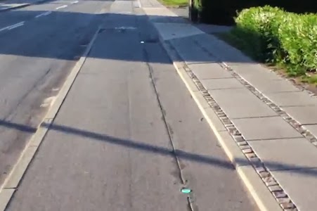
(5) Lane Lights on Humlebakken & Hadsundvej
On the east side of Hadsundvej, heading toward Humlebakken,
there are ten LED lights installed in the grade-separated bicycle lane,
starting 140 meters from the intersection. When these lights are illuminated
green, bicyclists are told that they will have a green light at Humlebakken.
When they are not lit, the rider should slow down, as they will meet a red
light. Moreover, if the rider sees that the light next to them is lit, but
those ahead are not, they should slow down until they are riding at the same
speed at which the lights illuminate. If they keep the pace that the lights light
up, the rider will arrive at the intersection just as the light changes to
green.
 |
| (10/23/2013 | Lane Lights on Hadsundvej | Credit: Cat Silva) |
According to the 2011 evaluation, 73% of respondents were
aware of this initiative. The remaining survey results may indicate that the
average users may not understand them or value their importance. 34% of respondents
said that they thought they were important, 34% also said they were not
important, and the remaining 32% did not provide a response. As is discussed in
the evaluation, this split may be due to the fact that the survey was given
soon after the initiatives were implemented.
This initiative is intended to test the functionality of
this technology to provide free flow conditions for cyclists. That there was
such a split in the importance of the lights, it is indicated that they are
only able to positively influence the flow of bicycle traffic if users actively
understand the technology.
(6) Route 100 Signposting
Along the route from the City Centre to the main campus of
Aalborg University, signposts were installed stating the name of the route as
“Route 100”, with “Universitetsruten” (the university route) underneath. None
of the CIVITAS planning documents for measure 51 discuss which project goals
these signs aim to meet. The most obvious interpretation of the provision of
wayfinding and branded signage is to improve the visibility and services along the
route. All road users along Route 100 are likely to see these signs and, over
time, may begin to associate the route with “Route 100”.
 |
| (10/12/2013 | Official Route Sign for Route 100 | Credit: Franziska T.) |
Just as there were no stated goals of this imitative, the
wayfinding and Route 100 signage was not evaluated in 2011. As such, there is
no present data on how effective or important Route 100 users find this
initiative. Due to this lack of users feedback, little can be accurately
determined about the effectiveness of this initiative.
 |
| (10/12/2013 | Directional Wayfinding Sign for Route 100 | Credit: Franziska T.) |
The first signpost along the route in the City
Centre is a directional sign indicating a right-hand turn toward Route 100,
with 4.2 kilometers to reach the Aalborg University. The placement and height
of this sign is a notable issue, concerning its usefulness and legibility. The
sign is surrounding by foliage that hinders oncoming bicyclists from reading
the sign. It is also located on the left hand side of the bicycle path that,
arguably, is not the location most suitable for a right-hand turn—that is,
riders must see it on their left-hand side shortly before they must safely take
a right turn.
(7) Reverse Duty Right of Way at Bonnesensgade & Fyensgade
At the intersection of Bonnesensgade and Fyensgade,
directional priority has transferred to traffic moving along Bonnensgade, as
opposed to Fyensgade. This intersection change was not included in the “tool
box” of initiatives described in the CIVITAS documentation of measure 51, but
it was investigated in the evaluation of the route. To that end, there is no
found documentation of the intention behind this change. As the priority has
changed at that intersection to decrease wait time for those traveling in both
directions along the path of Route 100, it can be extrapolated that this
initiative is intended to create free flow conditions for bicyclists and may
also have been intended to increase traffic safety.
According to the 2011 evaluation, 46% of respondents were
aware of this initiative and 29% feel that this intersection improvement is
important. Most survey respondents stated that they “Don’t Know”, and the evaluation
states that bicyclists reported feeling “insecure, uncomfortable and unaware”
and that “accidents seem unavoidable”. Although most were unsure if this was
important and expressed discomfort, the overall commute trip time for bicyclists
has reduced by an average of 12 seconds along the Route 100 corridor after the
spring of 2011. This is reduction amounts to approximately 26% shorter stop
times heading in both directions.
 |
| (10/12/2013 | Reverse Duty Right of Way at Bonnesensgade & Fyensgade | Credit: Franziska T.) |
The evaluation describes the bicycle filter lane and this
improved intersection to be the most impactful on this decrease in travel time.
The filter lane only provides free flow for bicyclists heading to Aalborg
University campus, yet that this reeducation is relatively equal in both
direction implies that the reversed duty to give way at Fyensgade may have a
strong influence on travel speed. That most respondents were unsure if the
intersection was making any difference could be due to the fact that this total
change does not feel like very much. Moreover,
as with initiatives like the lane lights, may not have been fully appreciated
by riders as the survey was given shortly after the infrastructure was
implemented.
As a part of evaluating the Route 100 project, as a whole,
accidents reported along the route were mapped out for the from 2005 to 2009
and again from 2011 to the first half of 2012. During the first period,
bicycles or mopeds driving in the bicycle lane were involved in 27 of 55
traffic accidents along the Route 100 alignment. It is then stated that, during
the latter period, less than half of the yearly average of traffic accidents
were reported—although no figures are provided in the evaluation report.
None of the reported traffic accidents looked at in the
evaluation after 2011 occurred at this intersection, yet the comments from the
survey indicate a concern among bicyclists. Part of this concern could be
partly psychological. There may be a lack of trust that traffic moving along
Fyensgade—the perpendicular street—will actually yield to traffic and bicycles
traveling along Bonnesensgade. Getting
used to having priority and becoming more confident when crossing this
intersection may be a process that could adjust how important this change is to
bicyclists and other road users over time.
Check Back Soon!
Over the next week, I will be looking closely at the results of my research project's evaluation and relating our results back to the 2011 evaluation….


