This past week I took a trip to the Faroe Islands with my boyfriend to explore the group of islands under the sovereignty of the Kingdom of Denmark. Although November is not necessarily the best time to visit the islands, it was a week long adventure full of beautiful views, odd encounters, and insane weather.
Although thereis much that I could share…it seems fitting to recount the various forms of transportation that we experiences in passing or in person during this trip… We made it to 8 of the 18 islands, so we did see quite a bit…but I should note that we very likely missed bits and pieces, but this post shows what I did see and experience during the week-long visit.
By Aircraft
Atlantic Airways provides the majority of connections to Vágar Airport on the Faroe Islands. A traveler can fly to this destination from Norway, Iceland, England, Spain, or one of three airports in Denmark. This time of year, we got the best price by flying out of Copenhagen and arrived in the North Atlantic Ocean less than two-hours after we took off.
When we landed the flew so incredibly close to the ground that it was somewhat nerve-wracking…but the decent is beautiful as you suddenly see a group of islands out in the vast ocean.
Something very interesting we learned after we arrived is that helicopters are considered a part of the normal transportation system. Privately operated by Atlantic Airways, helicopter transportation is available between 10 destinations across the 18 islands. A ticket is around $35 per person, making the trip quite reasonable. Seats are prioritized for locals - as there are some who rely on the mode to get to their remote homes and have groceries delivered - but tourists are able to book a seat and have the chance to see the islands from above. An interesting thing is that you can only take a helicopter one-way on a given day. This means that you need to plan for a place to stay - which is difficult to impossible in some places - and/or you need to plan for a ferry back to home-base that day or the following day. There are flights on the helicopter every Sunday, Monday, Wednesday, and Friday - however during this time of year Monday flights are not in operation. Trying to take advantage of this quick and exciting form of transportation, we had booked a helicopter on from Torshavn to Klacksvik on a Wednesday afternoon. Unfortunately, the weather was not favorable and the flight was cancelled, causing us to loose our chance to experience this unique aspect of the visiting the Faroe Islands. Although I have no photos of this non-occuring-experience to post, I will share a video I found on YouTube that captures what we may have experienced.
(09/24/2009 | Faroe Islands Helicopter | Credit: Kovboyfilm via YouTube)
By Bus
One very neat thing about visiting the Faroe Islands was how seeing how well different modes of transportation are coordinated. After every arrival at Vágar Airport, bus number 300 leaves from the airport, transporting arriving passengers to Tórshavn, largest town and the capital of the Faroe Islands. The bus literally waits until passengers have picked up their bags and the airport gives an announcement letting passengers know when the bus is soon departing. You can purchase a one-way ticket for this hour long journey for $16, but we opted to purchase 7-day passes for $127. These passes allow for unlimited use of all buses and ferries operated by Strandfaraskip - the national public transportation company.
The bus system was impressive, in that it connects nearly every corner of every island, with 20 different bus lines operating throughout the country. On top of that, in Tórshavn there are 5 bus routes that operate from around 6am to 11pm on weekdays and are always free to use. While this local system appeared pretty reliable, all of the national bus lines do not run all that often. The bus to and from the airport runs pretty regularly, but on some islands there are only 2 or 3 trips daily. As a resident, this likely works fine. But as a tourist, this means careful trip planning is necessary, as a great many towns and villages do not provide any where for you to stay over night should you miss the last bus.
(11/09/2013 | Bus Stop Pavement Marking | Credit: Cat Silva)
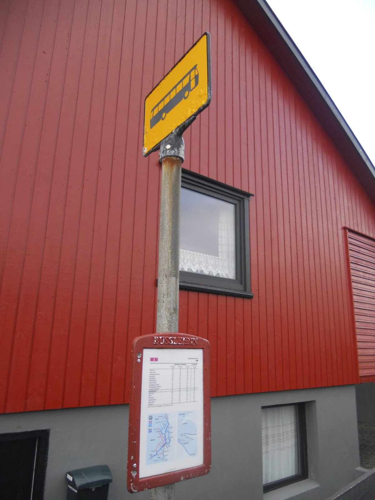
I really liked the bus stops we saw in Tórshavn. At stops where there was enough space in the roadway for a short-term lay-over space for buses, there was a great pavement marking on the street. The bold, bright white marking is a clear sign that it is a space for busses, not cars. At these more significant stops, there was usually a bus shelter provided for waiting passengers.Where there was not a shelter provided, a pole with a sign signals where the stop is. The stops for the free buses in Tórshavn were indicated by a yellow sign with a bus icon. These stops always displayed a time schedule posted and the bus numbers are posted on the time schedule.
(11/09/2013 | Local Bus Stop Pole in Tórshavn | Credit: Cat Silva)
It was a little different for the national buses operated by Strandfaraskip. The sign for these routes were blue throughout the islands - which is the same as what you see in some places around Denmark. At some stops, there were shelters and at others there were only bus stop poles. From those stops I saw, there were no bus numbers or time schedules posted. In some ways, it is shocking that there is so little provided at some stops. But, the locals, the regular users, understand the system and know how to navigate it. And as for tourists, it's a little confusing, but it worked really well for us. The drivers knew we were tourists and an overt effort on their part was made to make sure we made to and from our destinations.
(11/11/2013 | Regional Bus Stop Pole in Tvøroyri | Credit: Cat Silva)
By Boat
As this is a place comprised of islands, it may come as no surprise that there are seven different ferry lines connecting the coastal towns and villages. On our second day, we took the ferry that leaves from Tórshavn to Nólsoy, the small island 4 km across the harbor. Although this ferry, called the M/F Ternan, can hold up to 95 passengers and 32 vehicles, there were only only 10 passengers and maybe 2 cars.
(11/10/2013 | Strandfaraskip M/F Ternan from Tórshavn to Nólsoy | Credit: Cat Silva)
After a short 25-minutes sailing, we docked in the small village of Nólsoy. From there we took a hike to Borðan, a lighthouse on the south end of the island from the 18th-century. Supposedly, the lighthouse keeper who lives inNólsoy walks out there every day…but we saw tire tracks and are pretty sure that the tourist office may not have been entirely accurate. Today, the lighthouse can be seen on commemorative coin worth 20 Danish Kroner issued by the Bank of Denmark in 2005.
(11/10/2013 | Borðan Lighthouse on Nólsoy | Credit: Cat Silva)
Then, on our third day we decided to hop on the early morning connection to from Tórshavn down to Suðuroy, the island furthest to the south. This ferry is the largest that operates in the Faroe Islands and is named M/F Smyril. Far larger than the first ferry we boarded, this boat holds up to 975 passengers and 200 cars. Before this ferry was built in 2005, there was no boat connection to Suðuroy and the 2 hour trip opened up opportunities for locals to commute to Tórshavn for work and play, as well as provided much easier access for tourists like myself. It takes nearly 2-hours and, out on the North Atlantic Ocean, this was one of the roughest ferries and most windy decks I have ever been on.
(11/11/2013 | Strandfaraskip M/F Ternan from Tórshavn to Tvøroyri | Credit: Cat Silva)
(11/11/2013 | Strandfaraskip M/F Ternan from Tórshavn to Tvøroyri | Credit: Cat Silva)
On a monday, the ferry does three trips back and forth from Tvøroyri to Tórshavn. Our plan was to make this a day trip…but as soon as we docked on Suðuroy, an incredibly nice woman on the ferry explained to me that the last ferry out was cancelled due to bad weather in Tórshavn. This meant, unless we stayed on the boat and went directly back, we would be stranded until the first ferry the following morning. We weren't about to loose the opportunity to see Suðuroy, so we hopped off the boat and settled into being stuck for the night.
It was that day that we learned why the Faroe Islands is know as the "land of maybe"…maybe the weather will cancel the ferry…maybe I'll get home tonight… And you know what, learning that was easily the best and most interesting part of our trip.
By Bicycle
I looked high and low the entire time we were on the island…but it turns out that bicycling is not a common mode of transportation used on these islands that tend to be extremely windy, prone to sudden rain storms, and are hill-filled and car dominated. Bicycle lanes were no where to be seen on roadways and the one time I thought I saw a bicycle rack, it turned out just to be a small gate. That said, I did uncover some evidence that a few lonely soles are out on their bicycles!
On the street parallel to SMS, the shopping mall in Tórshavn, there was a shared-use path for bicycles and pedestrians. We didn't see any bicyclist using it that day, but it was the first and only piece of true bicycle infrastructure that I saw during the entire trip.
(11/09/2013 | Faced Bicycle Lane Marking | Credit: Cat Silva)
Where this path ends, there is one very faded bicycle pavement marking...
And as we walked back to the village of Nólsoy, I saw couple of child playing on their bicycles. One nice thing about small village on a small island is that it's save to leave the bicycles unlocked and parked in the middle of the street…
Getting around by car is easily the most common form of transportation on the Faroe Islands. The country is well connected roads winding around the islands, providing access from the largest towns to the smallest villages. The infrastructure is a little complicated, but the biggest danger are the sheep that freely wander around all the islands grazing on the grass and slowing down traffic when they try to cross the roads.
(11/08/2013 | Windy Road on Vágar | Credit: Cat Silva)
With the exception of three incredible small islands with few inhabitants, all the islands are either connected to their adjacent neighbor via a ferry or roads. Only two islands Streymoy and Esturoy are connected with an over-water bridge. And in the north, the island of Borðoy is connented to Kunoy and Viðoy with land bridges. Where the distance between islands is not short enough, the population has invested in subsea tunnels.
And then there are the tunnels. Beginning in 1963, the Faroese have invested in tunnels through mountains on 7 islands. The first one built is 0.9 miles long and is located on Suðuroy. I'm fairly certain this is the tunnel we drove through this tunnel on a bus ride from Tvøroyri to Sumba. Today, the mountain tunnel is just over 2 miles long. Many are two-way, but not all of them. On the northern islands the tunnels have one lane, with priority given to one direction. Drivers traveling in the direction without priority must yield to oncoming vehicles by pulling into turn-outs that were located every eight of a mile - I think. There was good signage showing where the turn-outs were, and all the drivers seemed to navigate the system well, but it kind of felt like playing chicken. I was grateful that we only experienced these one-way tunnels as passengers, not drivers!
The first subsea tunnel connects Vágar to Streymoy. It is 3 miles long and was built in 2002 and connects Vágar to Streymoy. Then, in 2006, a second tunnel was built between Borðoy and Esturoy
and is an impressive 3.8 miles long! One very cool thing about the newer tunnel is that, about half way through, there is aolorful light show designed by artist Tróndur Patursson, making the long ride more interesting for drivers and passengers. We heard that there is talk of building more tunnels, but they have been an expensive investment…so Maybe there will be more tunnels…or Maybe not...
I wish I had photos to share…but it was hard to take a photo of a dark tunnel from a moving vehicle…
By Foot
For a scarcely populated string of islands, the Faroe Islands was not always the most comfortable place to be a pedestrian. In Tórshavn, we felt like targets nearly every time we tried to cross a street. Even walking in the pedestrian core, it was necessary to watch out for drivers who were visibly irritated that you are in the way. We thought we were going to encounter quite town life, but instead there was a hurried, big-city feeling, only without any real traffic. We stayed at a hostel about a 20-minute walk uphill from the town and I was happy to see pedestrian wayfinding point us to a short-cut up. The only problem with this wayfinding is that once we made it up the first leg, there wasn't a second sign pointing to the unlit trail through stand of trees. It took us about 5-minutes to decide if it was the right way to go or not, and although it was, it was a little silly that they didn't add a second wayfinding sign to keep visitors on the right path.
(11/09/2013 | Wayfinding to our Hostel | Credit: Cat Silva)
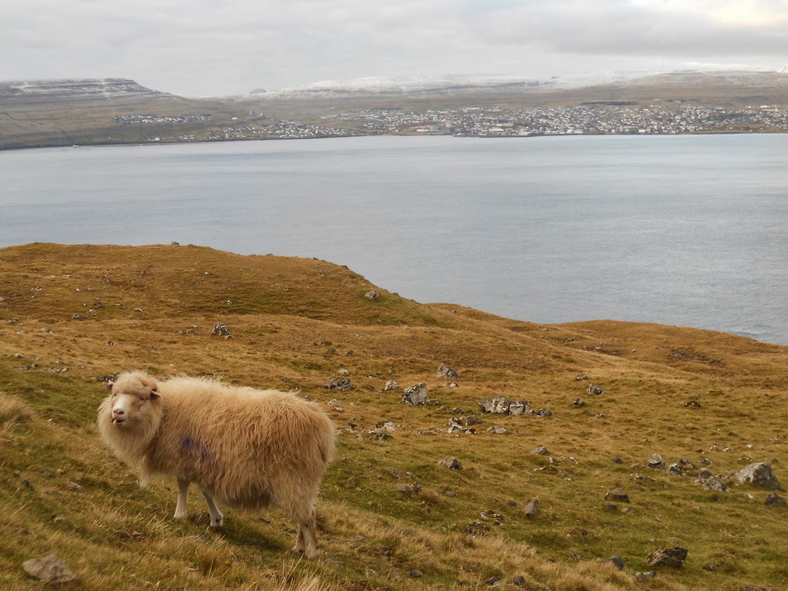
But there is one place where the pedestrian finds home is out on the hills, away from the towns and villages…and some of the you can only see up in the fields with the sheep.
(11/10/2013 | Sheep on Nólsoy withTórshavn in the Background | Photo Credit: Cat Silva)
A survey of 111 island communities given in 2007 by National Geographic determined that the Faroe Islands is the best, as it is "authentic, unspoiled, and likely to remain so." I will note that it is difficult to spoil nature when there is a small population and the soil is infertile…but nonetheless, there is some truth in the survey results.
(11/10/2013 | Hiking on Nólsoy | Credit: Cat Silva)
The hiking does offer some peaceful reprieve from the chaos of the roadways! There are some hikes on the northern islands that could be pretty treacherous, but many are exceedingly simple and approachable. The hike we did on Nólsoy, for example. was mostly flat, with only a few small hills to climb. There are carins guiding The hardest part about the hike was making it through the wet lowlands that used to be harvested for peat and traversing across the small streams of water. And the best part was spending a day following sheep on the hills, miles away from anyone else, with beautiful views of the North Atlantic Ocean in the background.
(11/10/2013 | Wayfinding on Nólsoy | Credit: Cat Silva)
If I ever make it back to the Faroe Islands…Maybe I'll do more hiking and see more of the quite corners of the islands…or Maybe it will rain the whole time...


No comments:
Post a Comment